


XFLY Lidar Scanner for Drone
The Stonex XFLY Lidar Scanner is a accurate and reliable solution for drone scanning.

The Stonex XFLY lidar scanner series integrates high performance Inertial Navigation System with camera and LiDAR for point cloud generation. Different customer’s need can be met by the choice of Hesai LiDAR XFLY120, XFLY300 or other sensors.
The processing platform contains a Wi-Fi interface, an embedded cellular modem for RTCM corrections, data logging software and a gigabit Ethernet network.
Equipped with a high-performance INS, it delivers clean point clouds even at high AGL. As a small, lightweight and low-power system, it allows the user to fly longer, adapting to the needs of any project. The post-processing software provides fully automatic point cloud generation.
200M AGL: Fly up to 200 meter above ground level.
ACCURACY: Thanks to high performances GPS-Aided INS, 3-5 cm point cloud accuracy can be achieved.
CAMERA: 24 MP camera adds RGB information to the data. Camera comes to the customer already calibrated and with these boresighting values already saved onto the device.
FLY & DRIVE: Different mounts are offered to support the assembly onto well-known UAVs and other platforms, like cars.
Among the compatible UAVs: DJI M210 – M300 – M350 – M600, Inspired Flight IF1200 Hexacopter, Freefly Alta X, Freefly Astro, WISPR Ranger Pro 1100, Sony Airpeak S1
PPK/RTK DUAL/SINGLE GNSS: Depending on customer’s application, choose whether you want single or dual GNSS antenna. For who wants to avoid post processing, Real Time Kinematic solution is also available.
Bundled Software: FLYpost:
The software observes and corrects misalignments between the INS and LiDAR, and georeferences the data into a geographic coordinate system. The post-processed INS trajectory, LiDAR scan files and camera images are converted to point clouds in LAS format for further processing.
Data samples:

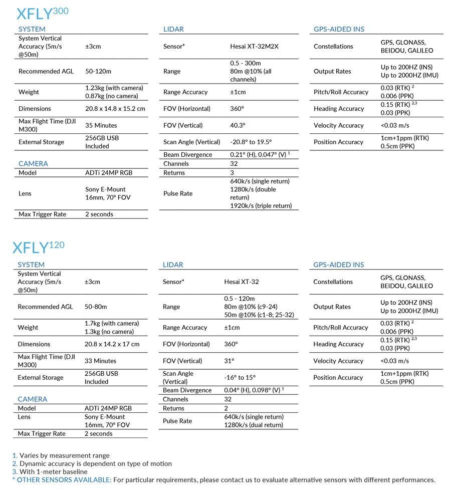
There are 2 XFLY Scanner solutions. The XFLY120 and the XFLY300. Data sheets below.
| XFLY120 Single Antenna - Lidar Solution for DJI M350 | |
| Standard Bundle consitsing of: | |
| XFLY120 Single Antenna Lidar Solution | 1 |
| XFLY Carrying case | 1 |
| HC977 Antenna, SMA cable (1m), mounting assemblies | 1 |
| XFLY Cable/connector | 1 |
| XFLY Storage USB drive | 1 |
| XFLY Power cable | 1 |
| XFLYpost - Annual license | 1 |
| DJI M300/350 Vibration isolator | 4 |
| XFLY300 Single Antenna - Lidar Solution for DJI M350 | |
| Standard Bundle consisting of: | |
| XFLY300 Single Antenna Lidar Solution | 1 |
| XFLY Carrying case | 1 |
| HC977 Antenna, SMA cable (1m), mounting assemblies | 1 |
| XFLY Cable/connector | 1 |
| XFLY Storage USB drive | 1 |
| XFLY Power cable | 1 |
| XFLYpost - Annual license | 1 |
| DJI M300/350 Vibration isolator | 4 |
Accesories are available. Please contact us with your requirements: