This complete GNSS Kit includes everything you need to survey with cm accuracy.
Stonex S850+ GNSS Receiver with IMU (Tilt Technology) included.
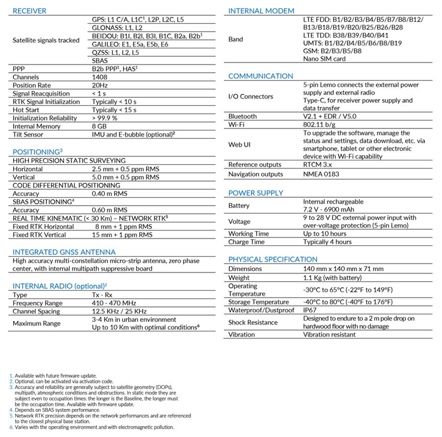
Equipped with an advanced 1408-channel GNSS board and capable of supporting various satellite constellations, including GPS, GLONASS, BEIDOU, GALILEO and QZSS. The Stonex S850+ GNSS receiver is the ideal solution for any surveying work in the field.
The receiver’s advanced design gives the S850+ excellent signal tracking and interference resistance capabilities. The advantages of portability and speed of operation make the S850+ GNSS receiver particularly suitable for field work in areas with complex terrain.
Stonex S850+ is equipped with all the necessary connections, has built-in Bluetooth and internal Wi-Fi capabilities; has a built-in UHF radio ( This would need the optional UHF Firmware activating at an additional cost ) and 4G GSM modem compatible worldwide. Stonex S850+ also integrates the IMU system that enables inclined measurement (TILT) up to 60° : quick initialization, fast and accurate surveying.
MULTI CONSTELLATION
Stonex S850+ with its 1408 channels, provides an excellent on-board real-time navigation solution with high accuracy. All GNSS signals (GPS, GLONASS, BEIDOU, GALILEO and QZSS) are included, no additional cost.
IMU TECHNOLOGY (INCLUDED)
IMU technology. Fast initialization, up to 60° inclination.
HIGH BATTERY CAPACITY AND USB TYPE-C
Stonex S850+ is delivered with a large capacity lithium battery and Type-C connector to recharge it easily.
RADIO (OPTIONAL)
An activation code can enable the integrated UHF on S850+, whose range can be up to 10km under optimal conditions.
RUGGED RTK
With IP67 certification Stonex S850+ will ensure operations in various kinds of extremely tough environments.
UT12P is a compact Android tablet, its efficiency and performances make it suitable for working in difficult conditions.
It has been designed to be handy and pocket-sized with a very visible screen, with which you can easily interact, using all the standard touch gestures. This device is optimized to work for an extended period without stopping, it is made for demanding tasks.
UT12P will work restlessly anywhere, anytime!
Need a light and pocket-sized PDA? The UT12P is certainly the right choice, in fact for its size, with the long side of just 192 mm and the weight of 360 g, it is suitable to be stored even in very limited spaces. Its compactness, however, does not affect its visibility and usability, its 6-inch display is suitable for direct finger touch, without additional auxiliary accessories, and it supports operations with gloves and wet hands. Its wireless connection capability is accompanied by a dual SIM card slot, NFC transmission capability and a GNSS sensor that can simultaneously read three, among the main satellite constellations.
In addition, the UT12P is equipped with an external connector for a GNSS antenna and USB Type-C. Despite its small size, it has a 14-pin POGO expansion available, useful for extending the functionality of the tablet.
The UT12P is a very resistant, drop-proof and shockproof device, with IP67 hardness, solidity and reliability. The buttons available allow advanced customization.
Stonex Cube-a field software.
Cube-a is Stonex’s solution for professional surveying and GIS which has been designed and developed for the Android platform. Thanks to the flexibility of the Android environment, we have been able to create a simple and intuitive user interface that makes surveyors ready for any work, saving time and increasing productivity.
Full support for touch gestures and the possibility to install it on Smartphones and Tablets are the keys to the success of Cube-a. It also includes support for many languages and adjusts its interface as from the current system language setting.
Stonex field solutions for GNSS RTK, GIS will make operators’ work quick and easy, ensuring high productivity in all jobs requiring precision and efficiency.
GNSS
Cube-a is compatible with all Stonex GNSS Receivers. Supports Rover, Rover Stop&Go, Base and Static modes. Various screens provide useful information on the status of the GNSS receiver including the position and the signal quality of the Atlas satellite.
Cube-a is a modular application which can be customized as needed: GNSS, Robotic and Classic Total Stations, GIS and 3D Modelling modules can be enabled to fulfill any customer need.
12month RTK Subscription.
RTK (real-time kinematic) Premium is our premium GNSS correction service enabling you to reach centimeter (1.5 cm) accuracy instantaneously on your GNSS device. RTK is currently the most advanced GNSS based precise positioning technique available and is provided by using state of the art network modelling software. Our RTK Premium network has a UK coverage and proven technology over the years. It is already used in several industries to improve productivity, efficiency and accuracy of positioning activities.
-
Centimeter accuracy (<1.5 cm);
-
Dense network with more than 2000 base stations all over the world;
-
High availability solution with an uptime of 99,98%
-
Proven technology supporting more than 15.000 users;
-
Standard RTCM format;
-
Easy to implement and compatible with every GNSS device in your industry;
-
Very competitive pricing.
All of this for just £5995 + vat.