Topolynx

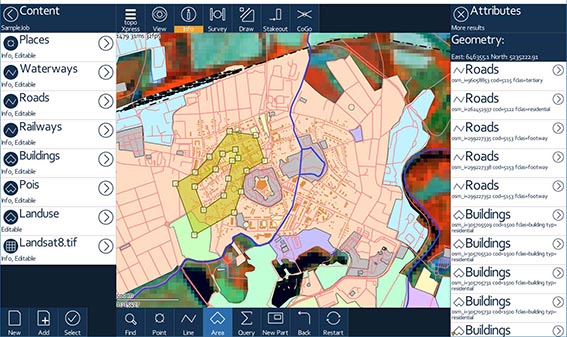
topoXpress is an efficient GIS and Surveying application for Windows®, Android™, macOS® and iOS®. It supports offline field data collection and online data processing in the office. topoXpress provides an intuitive and responsive user interface, portable cloud access, fast thematic mapping, GNSS surveying, stakeout and CoGo functions, smart forms, calculated fields on all platforms.
Same rich functionality
for GIS data collectors and
Surveyors on both platforms.
Use your mobile phone,
tablet, GNSS receiver to
collect data in the field!
Offline work, large datasets,
quick & responsive interface.
System requirements
Android OS:
Android 4.4 and up
CPU: minimum 512 Mhz
Display: minimum 800x480
RAM: minimum 512 MB
Windows OS:
Windows Vista, 7, 8, 10
CPU: minimum 1 GHz
Display: minimum 800x600
RAM: minimum 512MB
Key features and benefits
Productive data collection: job templates, GNSS surveying, stakeout,
intelligent forms, calculated fields, lists, GoGo, GIS functions.
Offl ine and Onl ine work (Google Drive, TMS, WMS, KML).
Customizable templates, layers and forms. Responsive user interface.
Extensive support of GNSS receivers, projection systems, geoids, shift grids.
Support of wide range vector (map, shp, mif, dxf, txt, csv, dat, dbf, tab, mid)
and raster (jpeg, ers, tiff, geotiff, png, lan, bil, bmp) formats.
Functionality
Job templates
Open existing jobs
Content manager
Thematic mapper
Settings, Help
Localization, Units
Projection systems
Custom projection
Information query
Calculated fields
Measuring positions,
lenghts, areas
Surveying
Multipart geometries
3D stakeout
Line stakeout
Intersections
Dividing features
Rectangular survey
Polar survey
Feature drawing
Connecting points
Polygon editing
GIS functions